Best GeoImgr Alternative: Free AI Photo Geotagging Tool in 2026
If you have ever used GeoImgr to add GPS coordinates to your photos, you already understand why image geotagging matters. Whether you are optimizing images for local SEO, organizing a photography portfolio by location, or documenting field work with GPS-stamped photos, geotagging is a practical part of many image workflows.
GeoImgr is a solid, focused tool. It lets you place a pin on a map, optionally add manual keywords and a description, and write the data into an image's EXIF fields. It supports JPG, HEIC, PNG, and WebP. For basic geotagging, it gets the job done.
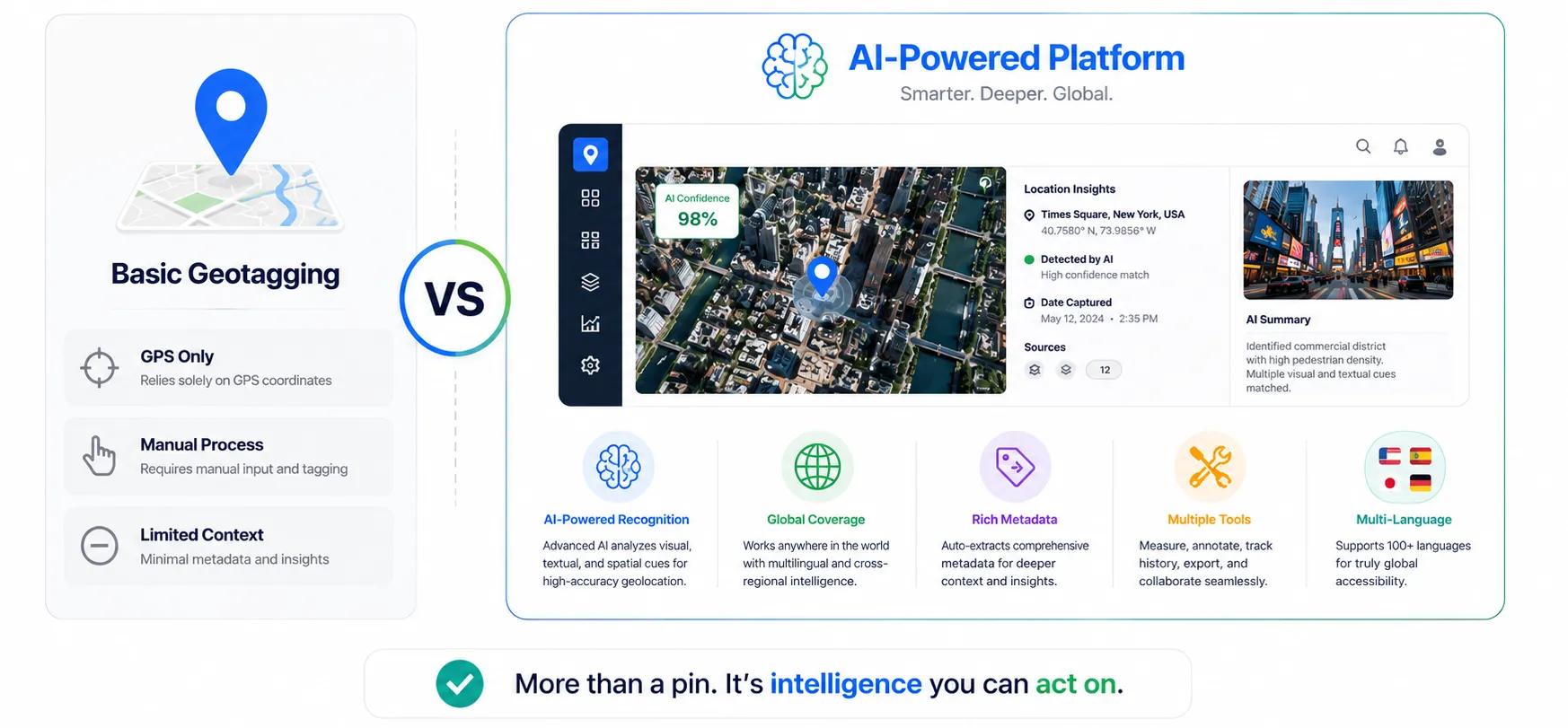
But if you need AI-generated content, IPTC/XMP metadata, multi-language tags, business SEO fields, or supporting image tools — GeoImgr stops short. This guide compares the two tools honestly and explains what makes GeoImageTagger a more complete option.
What GeoImgr does
GeoImgr is a straightforward browser-based tool for geotagging photos that has been running for over 10 years. You upload an image, place a pin on a Google Map (or search for an address on the Pro plan), and optionally type in manual keywords and a description. Then you click "Write EXIF Tags" and download the file.
It supports JPG, HEIC, PNG, and WebP uploads. The Free plan allows 5 photos per day (one at a time). The Pro plan ($12.90/month) allows 1,000 photos per month with batch uploads and Google Places search.
For simple, manual geotagging, GeoImgr works well. However, it has limitations that become obvious once you need more than basic EXIF fields:
- Manual only — there is no AI to detect where a photo was taken or suggest locations
- Manual keywords and descriptions only — you type them yourself; there is no AI generation
- EXIF only — no IPTC or XMP — it writes to EXIF DocumentName and ImageDescription, but does not write IPTC keywords, IPTC captions, XMP fields, or structured location metadata
- No image optimization tools — no compression, conversion, editing, or watermarking
- No dedicated metadata viewer — you can see existing geotags, but there is no full metadata inspector showing all EXIF, IPTC, and XMP fields
- No multi-language support — descriptions and keywords must be typed manually in one language
- No business SEO fields — you cannot add business name, address, phone, or website metadata
- Single-purpose — it does one thing only, with no supporting tools around it
For users who need a broader image metadata workflow, these gaps add up quickly.
What GeoImageTagger offers instead
GeoImageTagger is an AI-powered image geotagging and metadata platform that goes beyond coordinates. It combines geotagging with AI content generation, full metadata editing, and eight additional free tools — all in one place.
AI-powered location detection and tagging
Instead of manually placing a pin every time, GeoImageTagger can automatically detect where a photo was taken using AI visual analysis. The AI examines landmarks, architecture, vegetation, signage, and other visual clues to predict the location — even when the image has no GPS data.
Once a location is detected or set manually, the platform generates:
- AI image descriptions — natural-language descriptions optimized for SEO and accessibility
- AI keyword tags — relevant tags based on the image content and location
- Business-context tags — if you enter a business name, the AI generates tags relevant to that business (e.g., a restaurant name generates food, dining, and hospitality tags)
All of this is generated in 9 languages: English, German, French, Spanish, Italian, Portuguese, Dutch, Polish, and Turkish. GeoImgr allows you to type manual keywords and descriptions, but there is no AI generation or multi-language support.
Full metadata writing — EXIF, IPTC, and XMP
GeoImgr writes to EXIF fields (GPS coordinates, DocumentName for keywords, and ImageDescription). GeoImageTagger writes to all three metadata standards — EXIF, IPTC, and XMP. Every processed image gets:
- GPS coordinates (latitude, longitude, altitude)
- EXIF description and tags
- IPTC keywords, captions, and location fields (city, country)
- XMP metadata
- Business SEO tags (name, address, phone, website)
This matters because many professional tools, stock photo platforms, and CMS systems read IPTC and XMP — not just EXIF. With GeoImageTagger, your images leave the platform with complete, cross-standard metadata packages that work everywhere.
Manual mode with unlimited usage
GeoImageTagger's AI tagging uses your daily quota (5 images/day on the Free plan, 1,000/month on Pro). But manual mode is unlimited on all plans. You can set locations, write descriptions, add tags, and edit metadata manually with no daily cap.
GeoImgr's Free plan caps all usage at 5 photos per day.
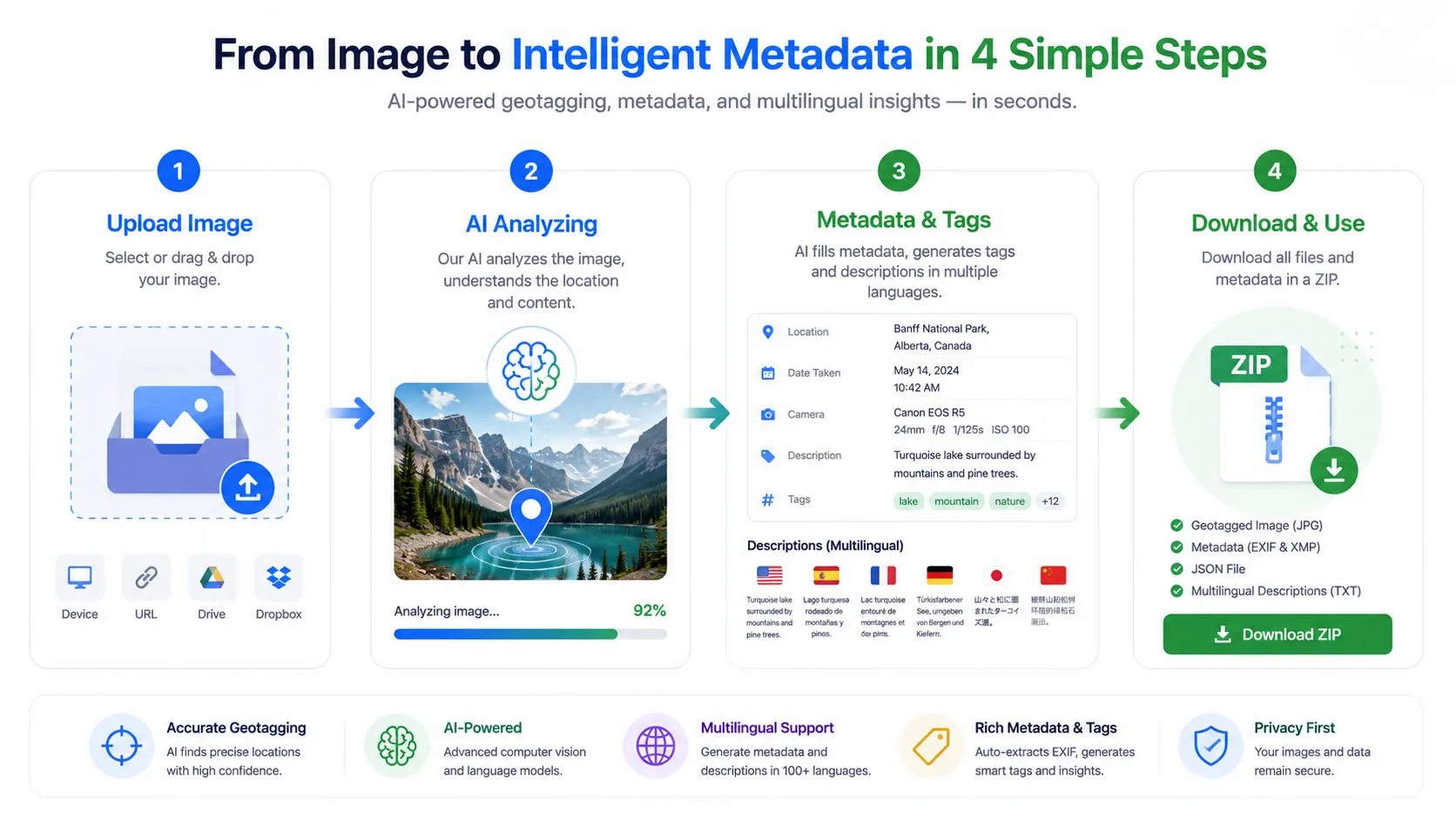 Workflow diagram showing AI location detection, description generation, metadata writing, and image export in GeoImageTagger
Feature comparison: GeoImgr vs GeoImageTagger
| Feature | GeoImgr | GeoImageTagger |
|---|---|---|
| Manual GPS geotagging | ✓ | ✓ |
| Manual keywords & description | ✓ (EXIF only) | ✓ (EXIF + IPTC + XMP) |
| AI location detection | ✗ | ✓ |
| AI-generated descriptions | ✗ | ✓ (9 languages) |
| AI-generated keyword tags | ✗ | ✓ (9 languages) |
| Business SEO tags (name, address, phone) | ✗ | ✓ |
| EXIF writing | ✓ (GPS + DocumentName + ImageDescription) | ✓ (GPS + descriptions + tags) |
| IPTC metadata writing | ✗ | ✓ |
| XMP metadata writing | ✗ | ✓ |
| HEIC/iPhone support | ✓ | ✓ |
| TIFF support | ✗ | ✓ |
| Bulk processing (Free) | 1 photo at a time | 2 images per upload |
| Bulk processing (Pro) | Multiple uploads | Up to 10 images per upload |
| ZIP + CSV export | ✗ | ✓ |
| Multi-language generation | ✗ | 9 languages |
| Manual mode (unlimited) | ✗ (5/day cap on Free) | ✓ (unlimited on all plans) |
| Free plan | 5/day, 1 at a time | 5 AI/day + unlimited manual |
| Pro plan pricing | $12.90/month | $10/month |
| Additional free tools | 0 | 8 standalone tools |
Eight free tools GeoImgr does not offer
One of the biggest differences between GeoImageTagger and GeoImgr is the ecosystem of free tools available alongside the main platform. GeoImgr is a single-purpose geotagging page. GeoImageTagger includes eight standalone tools that are free to use with no account required:
- Metadata Viewer — inspect EXIF, GPS, IPTC, and XMP metadata from any image file, entirely in your browser
- EXIF Remover — strip GPS, camera info, and hidden metadata for privacy, with selective removal options
- Metadata Editor — edit any EXIF, IPTC, or XMP field directly in a notepad-style interface
- AI Location Finder — upload any photo and AI will analyze visual clues to detect where it was taken
- Image Compressor — compress images with metadata preservation using browser-side MozJPEG, OxiPNG, and libwebp
- Image Converter — convert between JPEG, PNG, WebP, HEIC, and TIFF formats
- Image Editor — crop, resize, rotate, adjust, remove backgrounds, and create social media graphics
- Watermark Tool — add text, logo, signature, or hidden steganographic watermarks to images and PDFs
These tools mean you can handle your entire image workflow in one place — from metadata inspection to geotagging to compression to publishing — without switching between different services.
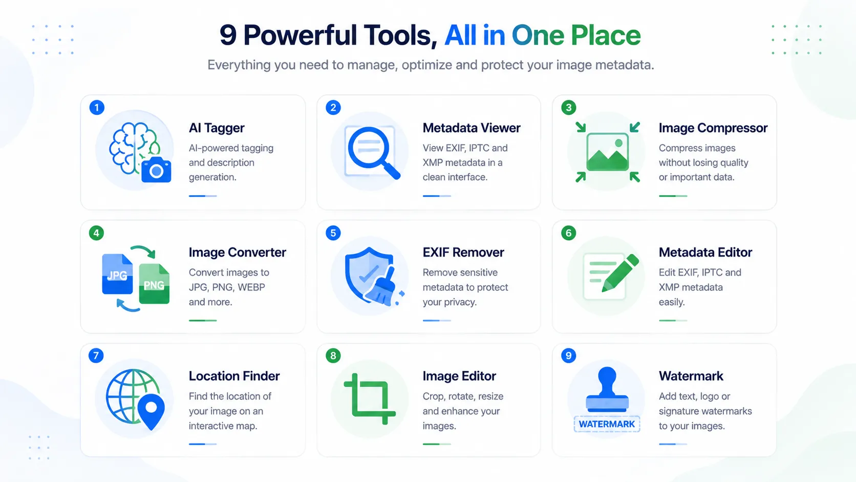 Overview of nine free image tools in GeoImageTagger including metadata viewer, EXIF remover, image compressor, converter, editor, and watermark
Pricing comparison
| Plan | GeoImgr | GeoImageTagger |
|---|---|---|
| Free usage | 5/day, 1 photo at a time, no search | 5 AI images/day + unlimited manual |
| Paid plan | $12.90/month — 1,000/month | $10/month — 1,000/month |
| Free tools included | 0 | 8 standalone tools |
| AI features | None | AI location, descriptions, tags |
| Google Places search | Pro only | All plans (manual search) |
| Cancel anytime | Yes (via Gumroad) | Yes |
GeoImageTagger's Pricing page has the full feature comparison between Free and Pro plans.
Who should consider switching
Not everyone needs to switch. If you geotag one or two photos per month and only need GPS coordinates, GeoImgr still works fine for that.
But if any of these describe your workflow, GeoImageTagger is the better fit:
- Local SEO professionals who need images with complete metadata packages (GPS, descriptions, keywords, business tags) for client locations
- Photographers who want AI-generated descriptions and tags in multiple languages for stock libraries or portfolios
- Agencies managing image assets across multiple locations who need bulk processing and CSV exports
- Content creators who want to compress, convert, and watermark images alongside geotagging
- Privacy-conscious users who need an EXIF remover or selective metadata stripping before sharing images online
- Anyone needing IPTC/XMP metadata — GeoImgr writes to EXIF only, while GeoImageTagger writes to EXIF, IPTC, and XMP for full cross-platform compatibility
You can explore the complete workflow on the How It Works page and see all capabilities on the Features page.
How to get started
Switching from GeoImgr to GeoImageTagger takes about 30 seconds:
- Go to geoimagetagger.com
- Upload your image (drag and drop or browse — supports JPG, PNG, WebP, HEIC, TIFF)
- The AI automatically detects the location, or you can search and click the map manually
- Review the generated descriptions, tags, and metadata
- Edit anything you want — descriptions, tags, GPS coordinates, business info
- Click "Write Metadata & Download" — your image downloads with all metadata embedded
- For bulk jobs, upload up to 10 images and export everything as a ZIP with a CSV summary
No credit card required. No software to install. The Free plan includes all features.
Frequently asked questions
Is GeoImageTagger really free?
Yes. The Free plan gives you 5 AI-processed images per day with all core features — AI location detection, descriptions, tags, and full metadata writing. Manual mode (setting your own location and writing metadata without AI) is unlimited on all plans. The 8 standalone tools are also free with generous daily quotas.
Does GeoImageTagger support HEIC (iPhone) photos?
Yes. Both GeoImageTagger and GeoImgr support HEIC/HEIF files from iPhones. GeoImageTagger additionally supports TIFF and offers tools to compress, convert, edit, and watermark HEIC photos — not just geotag them.
Can I use GeoImageTagger without creating an account?
Yes. Anonymous users can process images and use all tools immediately. Creating a free account increases your daily quota and gives you access to your processing history.
What metadata does GeoImageTagger write compared to GeoImgr?
GeoImgr writes GPS coordinates to EXIF, plus optional manual keywords (EXIF DocumentName) and a manual description (EXIF ImageDescription). GeoImageTagger writes all of that plus IPTC keywords, IPTC captions, IPTC location fields (city, country), XMP metadata, and optional business SEO tags (name, address, phone, website). The AI also generates descriptions and tags automatically in 9 languages. This gives search engines, accessibility tools, and content management systems much more structured information about each image.
Does GeoImageTagger work for local SEO?
Yes. The platform is specifically designed for local SEO workflows. You can add business name, address, phone, and website as structured tags alongside GPS coordinates and AI-generated descriptions. For a detailed guide on how geotagging fits into local SEO, read How to Geotag Photos for SEO, Local Businesses, and Photographers.
Conclusion
GeoImgr is a simple, useful tool for adding GPS coordinates to photos. If that is all you need, it works.
But if you need AI-powered location detection, AI-generated descriptions and tags in 9 languages, full EXIF/IPTC/XMP metadata writing, business SEO tags, bulk processing with ZIP and CSV export, and eight additional free image tools — GeoImageTagger does all of that in one platform, starting at $10/month for Pro (compared to GeoImgr's $12.90/month).
The Free plan is genuinely free. Manual mode is unlimited. And the eight standalone tools mean you can handle your entire image workflow — from metadata inspection to geotagging to compression to publishing — without leaving the platform.
← Back to Blog